
Chiang Mai literally means “new city” and has retained the name despite celebrating its 700th anniversary in 1996. King Meng Rai the Great founded the city as the capital of the Lanna Kingdom on Thursday, April 12 1296 around the same time as the establishment of the Sukhothai Kingdom. King Meng Rai even conferred with his friends, King Ramkhamhaeng of Sukhothai and King Ngam Muang of Phayao before choosing the site where the capital of the Lanna Kingdom was to be founded. Henceforth, Chiang Mai not only became the capital and cultural core of the Lanna Kingdom, it was also to be the center of Buddhism in northern Thailand, King Meng Rai himself a very religious leader who even founded many of the city’s temples that remain important to this day. Chiang Mai is one of the few places in Thailand where it is possible to experience both historical and modern Thai culture coexisting side by side: the city features centuries-old chedis and temples next to modern convenience stores and boutique hotels. This dichotomy is best appreciated within the moat-encircled old city, which retains much of the fortified wall that once protected the city center as well as the four main gates that provided access to the former Lanna capital city. Strangely, for many years tourists had mistaken Chiang Mai simply as the base from which they could plan trekking and rafting trips to hill tribe villages and explore other provinces. Once in Chiang Mai however, tourists are surprised by the fact that there are so many things to discover other than its beautiful and historic temples. Intriguing diversity among ethnic tribes, a number of elephant camps, many cooking & massage schools, numerous outdoor activities, a variety of handicrafts workshops, various cultural performances, and breathtaking scenery make Chiang Mai one of Asia’s most attractive tourist destinations. The phrase "a day in Chiang Mai is enough to see things around town" was once a common expression. Today, two weeks in Chiang Mai may not be long enough for travelers to experience all that Chiang Mai has to offer.
The old city of Chiang Mai is a showcase of the north’s fascinating indigenous cultural identity that includes diverse dialects, a delectable cuisine, distinctive architecture, traditional values, lively festivals, numerous handicrafts workshops, northern style massage, and classical dances. Chiang Mai city features old-world beauty and charm as well as modern luxury and convenience. In addition to centuries old temples and some outstanding shopping opportunities, Chiang Mai is also blessed with pristine natural resources including mountains, waterfalls, and rivers. The presence of numerous hill tribes that feature a wealth of unique cultures enhances Chiang Mai’s distinctive diversity. Hill tribe trekking, often combined with river rafting and elephant riding has always been one of Chiang Mai’s greatest tourist attractions. Nowadays there are innumerable activities and attractions both in the city and the surrounding province, including massage instruction and golf. Moreover, visitors can visit workshops where they can learn about the production of silk or silver, and purchase memorable, hand crafted souvenirs. With such a diverse range of attractions and an equally grand selection of dining and accommodation options, Chiang Mai is a place where both backpackers and luxury tourists can enjoy the ultimate Thailand holiday.
- Many elephant camps do not engage in Elephant-friendly practices. Avoid patronizing camps that exploit Thailand’s elephants.
- Patronizing the Royal Folk Arts and Crafts Training Center in Mae Hong Son benefits both villagers and the authenticity of native arts.
- The admission fee for the Chiang Mai Zoo is not inclusive of the fee to visit the Pandas.
- If you plan on arriving in Chiang Mai during the Songkran festival (April 13-15) make sure you pack everything in plastic prior to placing it in your luggage.
Don't Miss!
Wat Chiang Man

Operating day : Daily
Operating time: 08.00 - 17.00
Category : Temple
Attraction Details : The oldest temple in Chiang Mai town, Wat Chiang Man was built in 1296 by King Mengrai, the founder of Chiang Mai. The temple is famous for its Lanna-style chedi supported by rows of elephant-shaped buttresses and an ancient and invaluable Buddha image named Phra Kaeo Khao. Wat Chiang Man is situated off of Ratchapakhinai Road in the northeast corner of the old city.
How to get there : By Car
Wat Chiang Man is situated off of Ratchapakhinai Road in the northeast corner of the old city.
Wat Phra Sing

Operating day : Daily
Operating time: 08.00 - 17.00
Category : Temple
Attraction Details :Wat Phra Sing, located on Sam Lan Road, houses the revered Phra Phutthasihing Buddha image cast in Subduing Mara. The Buddha image is now enshrined in Viharn Lai Kham. During the Songkran festival, each April 13-15, people process the most sacred Buddha image around Chiang Mai town for traditional bathing.
Formerly, this area was a Wat Li Chiang Market until 1345, King Pa Yu, the fifth king of Mengrai Dynasty commanded to built this temple and a 24-feet chedi containing his father’s ashes. The temple compound includes the lovely Viharn Lai Kham featuring exquisite woodcarvings and northern-style murals paintings, a magnificent scriptural repository with striking bas relief, and a circular stupa (in Lankan bell shape).
Wat Prasat

Operating day : Daily
Operating time : 08.00 - 17.00
Category : Temple
Attraction Details : Wat Prasat, located on Inthawarorot Road near Wat Phra Sing. The temple houses traditional Lanna architecture chapel, the chapel roof is decorated in colourful glasses and wooden craved lions. Wat Prasat houses one of the rare Lanna arts’ Buddha image.
Wat Chedi Luang
Operating day : Daily
Operating time : 08.00 - 17.00
Category : Temple
Attraction Details : Wat Chedi Luang houses the largest chedi in Chiang Mai. The temple is located right in the middle of the city and was built in the reign of King Saen Mueang Mak, the seventh king of Mengrai Dynasty. The 98-metre tall and 54-metre wide chedi was built in the reign of King Tilokkarat. The construction was completed in 1481. In 1545 the chedi was collapsed due to an earthquake during the reign of King Jiraprapa. The chapel in the front was built by Chao Khun Uba Lee Poramacharn (Sirichantathera) and Chao Kaeo Navarat in 1928. The magnificent methodological serpents ramble from the entrance of the chapel to its door on both sides. It is believed that they are the most beautiful man-made serpents in the northern Thailand.
Wat Phan Tao

Operating day: Daily
Operating time: 08.00 - 17.00
Category : Temple, Historical Sites & Monuments
Attraction Details : Wat Phan Tao, located on Phra Pok Klao Road beside Wat Chedi Luang. The temple was a throne hall for King Mahotara Prateth, thus the peacock shaped doors were built. It is believed that peacock is a symbol of king.
Wiang Kum Kam

Operating day : Daily
Operating time : 08.00 - 17.00
Category : Historical Sites & Monuments
Attraction Details : Wiang Kum Kam is an ancient city that was built in the reign of King Mengrai in 1286. The city was surrounded by ditches in every corner and they were used as reservoirs. From the discoveries, there are 20 ancient remains in and around Wiang Kum Kam include buildings and temples of Wat Chedi Liam, Wat Chang Kham, Wat Noi, Wat Pu Pia, Wat Ku Khao, Wat E Kang, Wat Hua Nong, and Wat Pu Song. The remains are dating from 21st –22nd Buddhist centuries.
Wiang Kum Kam is located in the southeast of Chiang Mai, between Km.3-4 along Chiang Mai-Lamphun route, Tambon Wang Tan, Saraphi district. Take the road at Nong Hoi Polce box to the Ko Klang Pa Kluai intersection and en route to Chedi Liam Police box. Wiang Kum Kam Information Center Tel: 0 5327 7322
Wat Chedi Liam or Chedi Ku Kham was built in 1288 in the reign of King Mengrai after he had authorised an administrative responsibility of Lamphun town to his minister, Aey Fah. King Mengrai established a town in the northeast of Chiang Mai for 5 years and then resettled a town near the Mae Ping River in 1277 and renamed it “Wiang Kum Kam”. In 1287, the stupa of Wat Jamthewi, Lamphun was rebuilt in Wiang Kum Kam for the locals to worship.
After that for hundreds years, the temple was left abandoned. In 1908, a Burmese tycoon renovated it, thus the temple has influences of Burmese architecture instead of its former Khmer style. Only some parts were rebuilt in Khmer architecture.
Chiang Mai Zoo

Operating day : Daily
Operating time : 08.00 - 21.00
Category : Zoos and Aquariums
Attraction Details : Chiang Mai Zoo is located next to Huai Kaeo Arboretum. It is a well-managed large zoo, which occupies the lower forested slopes of Doi Suthep Mountain. The zoo contains more than 200 types of Asian and African mammals and birds. The most popular star here is a couple of panda, the friendship Chinese ambassador. The zoo provide mono-rail service within the area of 2 kms. Additional, the twilight zoo is open 6.00 p.m. to 9.00 p.m. The newly aquarium on its area 10 rais, which housed the longest underwater automatic tunnel of Asia with 133 meters, and will accommodate both sea and river fish and animal from various areas; such as the upper mountain ranges of Northern Region, Khong River Basin, Amazon River Basin, the plain land of mangrove and from the underwater world. Moreover, the Nakhon Ping Bird Aviary, a large bird aviary with an area of 6 rai that is also the largest one of its kind in Thailand. This offers an opportunity to see and study about the nature of more than 132 local and international species of bird in the midst of a natural environment with a waterfall.
The zoo is open everyday from 8.00 a.m. to 7.00 p.m. Admission fee for adult is 100 baht, and children fee is 20 baht. Restaurants and a camping site are available. For more details or advance booking contact Tel: 0 5322 1179, 0 5322 2283 www.chiangmaizoo.com
Sao Din Na Noi

There are many natural geological occurrences from soil erosion in Thailand such as Lalu in Sra Kaew, Phae Muang Phee in Prae, Fung Ta in Payao or Pa Chon and Kiw Suer Ten at the Mae Wang National Park, Chiangmai. The latest one that was recently discovered is Sao Din Na Noi in Amphur Na Noi in Nan province.
Sao Din Na Noi or locally called “Hom Jom” was created by erosion of wind and rain. It is similar to Phae Muang Phee. It is assumed that Sao Din Na Noi was made between 10,000-30,000 years ago and used to be under the sea. The natural phenomena Sao Din Na Noi are an interesting sight to see. Enormous holes, walls, and pillars of earth and rock can be seen here. It is orange-red in many different shapes. All of these are located in a 20-rai area, which is surrounded by pine forest. During winter, the forest turns into yellow, red, orange and brown which is in contrast with the blue color of the sky. There is a natural path created for tourists.
Stone bracelets and ancient axes have also been discovered here which are now preserved at the National Museum of Nan province. We can assume from this evidence that Sao Din Na Noi was inhabited during the Stone Age.If you have a chance to come to the park, you should also visit Sao Din Na Noi. Even though it is not a popular tourist stop, you can still visit here all year especially during winter. Apart from Sao Din Na Noi, there are also many places to visit such as the Pa Chu in the north, Doi Samer Dao in the National Park of Nan, Baan Pak Nai in the south, and Sirikit Dam. You can also visit Phae Muang Phee and worship Pra Tad Chor Hae at Prae province.
Location and travel routes
Sao Din Na Noi is located at the southwest side of the National Park of Nan province. From the city of Nan, go south along 101 highway to Amphur Wiang Sa. After that take the 1026 highway to Amphur Na Noi and turn left to the 1083 highway, drive along the 1083 highway for about two kilometers, you will see a sign for Sao Din Na Noi on the right side. Turn right into Baan Nor Haa, drive pass Baan Tae and you will arrive at Sao Din Na Noi. The total distance is around 60 kilometers from the city of Nan. For those who travel from Prae, use the route to Amphur Rong Kwang on 101 highway for 24 kilometers. Then, turn right to the 1217 highway and 1216 highway to Amphur Na Noi for 56 kilometers. After reaching Amphur Na Noi, use the same route mentioned above.
Pha Hom Pok National Park

The name was changed from Fha Hom Pok National Park because of the name of a high hill at Dan Lao Moutain Range. The highest hill in the park is about 2285 meters above sea level. On the top of the hill, there is granite and a shallow layer of soil. It is quite windy all the year. and the ridge road being parallel with the border of Thailand-Myanmar. It is interesting to visit the national park in winter because of the cooler weather, mountain mists and migratory birds such as purple cochoa, brown-breasted bulbul, blue peacock, and brown gorgon, turdus ruficollis, grey-winged blackbirds, and chestnut thrush come here. There are rare orchids which are hard to find in other parts of Thailand. There are some attractive butterflies such as the kaisar-i-hind that only appear here.One of the attractions at Pha Hom Pok National Park is the Natural Hot Spring. There are several hot springs within a ten acre area. The water has a high sulphur content and possesses curative and restorative properties.
How to Get There
The office of Pha Hom Pok National Park is in Fang District, Chiang Mai Province. From the city of Chiang Mai, take Route No. 107 (Chiang Mai-Fang). When you arrive in Fang-Mon Pin (about 3 kilometers), turn right onto Route No. 4054 (about 8 kilometers) to arrive at Fang Hot Spring where can be found the office of Pha Hom Pok National Park.The travel around Pha Hom Pok National Park, you have to use a four wheel drive along Sai Fang-Ban Huai Bon Road. When you arrive in Ban Huai Bon, go straight on for about 5 kilometers. Then, turn right and go 17 kilometers and you will reach the watershed management of Doi Pha Luang. If you turn left and drive about 5 kilometers, you will see the camping area of Kiu Lom.Walking to the peak of the mountain will take time about three hours with three kilometers for the return trip.If you want to drive to the top, you have to go up before 3.30pm and drive in just a pickup. You can take a service car and pay 1800 bath per eight people (stay overnight). Fires are not allowed on the grass. The National Park provides rented charcoal stoves.
Accommodation
Resorts are available only at Fang Hot Spring (the office of national park). On the top of the mountain, just tents are allowed. You can use the bathrooms, mineral baths, and massage which are open daily from 7.30am–7pm.
Address
Pha Hom Pok National Park 224, Mu 6, Phong Nam Ron Sub-district, Fang District, Chiang Mai Province, 50110 Contact number: 08 6430 9748 , 0 5345 3517-8 Fax: 0 5345 3517 Email: doiphahompok.np@hotmail.com
Doi Mon Jong

Doi Mon Jong has a beautiful landscape filled with mountain ranges. The route to this mountain is beautiful with the shade of sunlight along the deep forest of Omkoi. The loveliness of the scenery is an attraction that makes visitors fall in love with this place. There are also fields of Rhododendron for the travelers to see. Rhododendrons are very hard to find in Thailand, one of the places where we can find them is Hua Sing peak, which is the highest peak on Omkoi. Rhododendrons will blossom in the sunlight, which is a very beautiful picture that tourists come to see especially during winter.
Doi Mon Jong is located in the Omkoi Wildlife Sanctuary, Musoe Forest Protection Unit, 131 Moo 2 Tambol Yangpiang, Amphur Omkoi, Chiangmai 50310. The route starts from Bangkok to Amphur Hot, Chiangmai. Then take the 108 highway and turn left to 1099 highway to Amphur Omkoi. After that drive to Musoe Forest Protection Unit and inform the officer about your visit in order to use the officer’s four-wheel car to Doi Mon Jong.
Note: Doi Mon Jong does not have any facilities for tourists. If you want to stay overnight you need to bring your own tents and food.
Doi Suthep
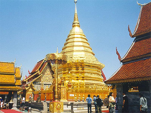
Doi Suthep, located only 16 km. from central Chiang Mai, is known to be the most comfortable mountain to visit in Chiang Mai since it takes only one day for a trip. You can take a bus from Chiang Mai University or Chiang Mai zoo if you are not driving. You will find many restaurants, shopping places, and several tourist attractions along the way, and so the popularity has increased with time.The high season is the late winter due to the most captivating view of the town of Chiang Mai from the top. February comes highly recommended, and the weather is not too cold to walk and relax. The top of nearby Doi Pui is also covered with winter flowers and gives the most exquisite picture at this time of the year.
Absorb the magnificent view at a few viewpoints along the way before reaching Wat Pratat Doi Suthep Worawihan. The temple is probably the most historically and religiously important place in Chiang Mai with the history dating back to the year 1384. The 360 steps of Naga Stairway and Pratat Doi Suthep Chedi, a tin-gold chedi that contains the Buddha’s relics, are hard-to-miss.
How to get there
From Chiang Mai downtown area, drive along Huai Kaew Road passing Chiang Mai University to Doi Suthep and Doi Pui. Doi Suthep – Doi Pui National Park provides a number of roads and trails for your enjoyment. Such routes include the Montatan Waterfall-Upper Srivichai Road-National Park Office tracking, trails for bird watching and Yang Pai Forest, roads for motor vehicles, routes for mountain bikes, and many other paths that can take you to many interesting places located in this vast national park.
Doi Luang Chiang Dao
Doi Luang Chiang Dao is located in the area of Chiang Dao wild life sanctuary. It is the 3rd highest limestone mountain in Thailand. Its height is about 2,225 meters from mean sea level. Doi Luang Chiang Dao is around 230-250 million years old. The rock texture is white-grey which come from sediment piling up which are formed with limestone. It is known that the Doi Luang Chiang Dao area was once a shallow sea.If looked at from aerial photographs, you will see the mountain ridge of Doi Luang Chiang Dao is horseshoe shaped encirclement. In the center is a narrow valley and around the line of the mountain is a sharp stone with chasms, and cracks which come from the chemical reaction of rain and limestone. There is a ravine called Ao Salung.
At the top of Doi Chiang Dao and Kiw Lom are two beautiful viewpoints to see the mountain mist on Doi Luang Chiang Dao. The best time to come is in the morning at the top of Doi Chiang Dao and then go to see the mist at Kie Lom another day. To reach the top of Doi Chiang Dao, it takes about 30-45 minutes walking from Ao Salung, the camp point, to the top. It is the best point to see the mist in the morning because on the top you can see a 360-degree panoramic view. At the east, is Kiw Lom, at the west it is Doi Sampeenong, at the south it is Southern Kiw Lom and at the north you will see Doi Pyramid and other ranges of small hills. The area at the top of the mountain has a path along which various plant can be seen. In March-April, the white roses will be in full blossom on the top of the mountain. And there are many kinds of beautiful birds for bird-lovers to photograph.
Doi Luang Chiang Dao is beautiful for the changeable color of the surrounding grassland, but there are also various forest flowers and rare birds to observe all along the way. Not only semi-alpine plant communities and the view of beautiful mountain mist there also is tourist attractions and activities in the area of the national park and the nearby area. Chiang Dao cave is recommended for a visit. There are three possible routes once inside the cave complex. Phra Non cave, Kaew cave and Meud and Mah cave. All these caves have beautiful stalactite and stalagmites. The other interesting places are Sri Sawal waterfall and Pong Ang hot spring.
Traveling
Doi Chiang Dao is located in the area of Doi Luang Chiang Dao wild life sanctuary, about 5 kilometers from the town of Chiang Dao, which is about 75 kilometers from Chiang Mai. From Chiang Mai downtown, take highway no. 107 (Chiang Mai-Fang) through Mae Rim district, Mae Malai market. Keep driving for about 30 kilometers and at 72 kilometers you will find the intersection, turn left along the way to Chiang Dao district, Muang Kong to Ban Chiang Dao cave for 5 kilometers and then turn left again along the way to Pha Plong cave temple for about 300 meters. Then, you will arrive at Doi Luang Chiang Dao wild life sanctuary.
Doi Ang Khang
Although situated in the far north of Chiang Mai and tourists have to go up and down mountain after mountain, Doi Ang Khang still maintains its popularity among nature lovers. The highlights of this famous attraction are winter plants and flowers that grow abundantly all year long. Doi Ang Khang is a part of Dan Lao mountain range along the border of Myanmar and maintains year round cool temperatures. Mountain mists can be always seen here and the place is perfect for winter plants. Apart from the first Royal Project of Winter Plant Research Station, which was founded in 1969, you can also see and learn about the interesting cultures of hill tribe people.
Nearby is Baan Koom, a small multi-racial village of Tai Yai, Burmese, and Chinese people. Tourists will find shops, souvenirs, and accommodation provided with friendly hospitality in this village. If you fail to make a reservation for your hotel in Doi Ang Khang in time, this village is also a good choice. Though the accommodation is not as luxurious, the place makes up in the extraordinary view. In the late winter in Doi Ang Khang, the changing colors of the forest lends the most gorgeous view with the exquisite wild Himalayan cherry blossoms or Thai sakura that bloom richly on the side of the road. Strawberry farms offer a welcome for tourists to try fresh picked fruit. For nature and bird lovers, Doi Ang Khang also has a nature trail which passes through a small forest and village farms abundant with local and migrating birds. The trail starts not far behind Mae Poe Water Source Management Department of Doi Ang Khang Agricultural Station.
How to get there
If coming by car from the Chiangmai-Fang road (Highway 107), turn left at an intersection around 137 kilometres (Mae Kha Market) and continue to Doi Ang Khang for a further 25km. It is a steep zigzagging asphalt road. Therefore, only vehicles in good condition with experienced drivers can make the trip. It's also possible to take a songthaew truck from Mae Kha to Doi Ang Khang, but departures are irregular and you'll probably need to charter one.
Doi Inthanon

Doi Inthanon is the highest mountain in Thailand, yet the easiest and most comfortable to visit, as there is good road access. Approaching Doi Inthanon the first landmark is Mae-Ya waterfall, one of the most beautiful and grandest in Thailand. It originates from the Mae-Ya River that flows down against rocks and cliffs over 280 meters high and 80 meters wide. At eight kilometers is Mae-Klang waterfall where tourists come to have a picnic in the cool shade. Close by is Brijinda cave containing exquisite, stalagmites and stalactites, and underwater Buddha statues. Vajiratan and Siritan waterfalls at 21 km offer stunning views of rainbows and thick abundant green forest even in the middle of the day.
The Inthanon Royal Project Research Station is situated in Mong Khun Glang village. The building is decorated beautifully with a winter plant glasshouse and offers cozy accommodation and a restaurant. Siripoom waterfall (originally known as Lao-Lu Fall among locals) at 30 km. gives a spectacular view of two streams of white water. On the right side of the road not far from Doi Inthanon National Park Office is a line of wooden stalls where villagers come to sell their agricultural products, fresh and processed, from early morning until the evening. This is called Mong market. Drive on for another 4.5 km. and you will arrive at Doi Pa-tang, twin cliffs on a mountaintop, another magnificent viewpoint of Doi Inthanon. Pra Maha Tat Napametaneedon and Pra Maha Tat Napaponpoomsiri are perfect spots for blossoms viewing and watching the sunrise and sunset.
There are both short and long nature trails in Doi Inthanon for tourists of all abilities and ages. Giw Mae Pan is a short trail of approximately 3 km. abundant with wild flowers such as rhododendron, white roses, and orchids that bloom colorfully in the late winter. You may also find Chinese gorals prancing in the morning if you’re lucky. In addition, Ang Ka Luang nature trail on the top of Thailand is 2,560 meters high and can be reached by car. The highlights of this trail are the moss and fern covered trees rhododendrons, and green-tailed sunbirds.
How to get there
From the centre of Chiang Mai, take Highway number 107 to Jomtong sub-district then take a right signposted Doi Inthanon.
Ngaem Cliff
If you want a place to view beautiful scenery and rare flowers, the route to Ngaem Cliff is perfect. The route to Ngaem Cliff is closed to tourists to visit by themselves, so the nature here is still beautifully preserved. Permission is needed and there must be an officer to guide the way throughout the visit.The Ngaem Cliff tour starts at the Radar center, an officer will take you down the two-kilometer route along the valley. At the beginning of the path, you will find a rain forest and after that, you walk around thirty minutes up the hillside. At this point, you will be able to see the beautiful scenery of Amphur Mae Jaem on your left and attractive views of Amphur Mae Warng on your right side. A little further on is Ngaem Cliff. Ngaem Cliff is a most beautiful viewpoint with a panoramic outlook. What is more, if you go there during winter, you will be able to see the beauty of Rhododendrons.
On the way back, the officer will use the same route, which will take around three hours altogether. At the radar center, there are many shops for you to stop at. If you still want to see some more beautiful scenery, you can take the route to Arng Ga and Giw Mae Pan.On the way back, you can also visit the Mae Klang waterfall, Vachiratan waterfall, and Nopponpoomsiri and Nopmaytaneedol stupas. Return to Chiangmai through Amphur Mae Jaem. The route to Amphur Mae Jaem also has many beautiful mountains and fields which are worth seeing. At Amphur Mae Jaem, there are also many temples, viewpoints and handmade woven cloth which are typical of this district.
Pha Chor

Pha Chor, Chiang Mai. Nature can create many unexpected wonderful things. The passing of time can change the topography of a place and can create strange sights. If you have visited Phae Mueang Phi in Phrae, Phang Ta in Doi Phu Nang National Park, Phayao, or Lalu in Sra Kaew, you can also see the same kind of rock sculptures at Pha Chor and Khew Sua Ten in Mae Wang National Park, Chiang Mai. Pha Chor and Kew Sua Ten are a natural phenomenon of eroded soil pillars. It is believed that this used to be the Ping River watercourse. When the river changed route the site became a hill from the river sediment that piled up into layers. When time passed, it eroded and became cliffs and soil pillars of strange shapes. Similar to Phae Mueang Phi in Phrae and Phang Ta in Phayao, Pha Chor pillars are thirty meters high around a canopy of forest and covers a large area.
To visit Pha Chor, drive to Yang Kram, Doi Lor district which is the location of the Park Security Guard Unit and contact the park officer to be guided through the site. It takes about one hour to travel through the attraction. Khew Sua Ten is another attraction that can be visited in the same trip as Pha Chor. With a similar natural sculpture, Khew Sua Ten is located about one kilometer away from Pha Chor in Yang Kram district and has similar beautiful scenery as Pha Chor with different designs, more pebbles and rocks that can be seen at a lower height.
For a stay over trip in the national park, you can choose to travel to Doi Pha Tang by trekking and staying the night on the mountain on the first day, and then return to Pha Chor and Khew Sua Ten on the second day. Doi Pha Tang is about 1,909 meters above sea level, located in Mae Win, Mae Wang district. Since it is the part of Doi Inthanon mountain range, the weather is cool throughout the year. Due to strong winds along the mountain ridge, there are no tall trees obscuring the view.For those who would not enjoy travelling on the mountain, after visiting Pha Chor, you can relax at the many waterfalls inside the park such as Khun Puay, Pra Duk Daeng, Phong Noy, and Phong Samid
Travel Information
Pha Chor is located in Mae Wang National Park, Doi Lor district, Chiang Mai province. From Chiang Mai city, take highway no.108 (Chiang Mai – Hod) for about 21 kilometers, turn right to Mae Wang district along rural highway no.12039 and no.10240 (Mae Win – Bo Kaew) for about 36 kilometers arriving at Mae Wang National Park with a fine macadam road all the way.
Travel Season All year, but is the most beautiful in winter
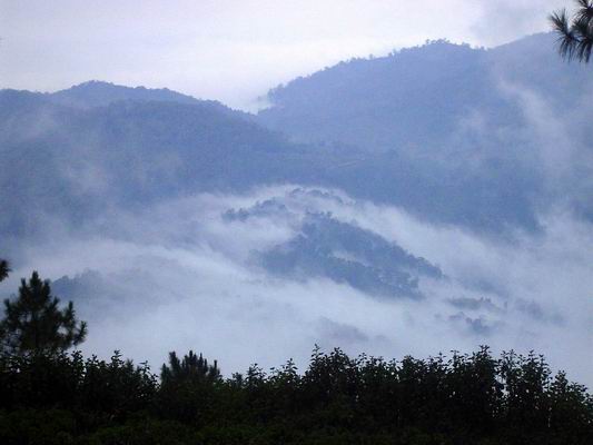
Huai Nam Dang: Misty Mountain Views

The Huai Nam Dang National Park is the eighty-first national park of Thailand. Huai Nam Dang is a chain of mountains from north to south in line with Chiang Dao mountain. Huai Nam Dang is from 500 to 1,962 meters above sea level. The highest mountain of Huai Nam Dang is Doi Chang which is the headwater forest. There are numerous streams such as Huai Mae Yen, Huai Mae Hi, Huai Mae Ping, Huai Mae Chok Luang, and Haui Nam Dang. All steams flow together to the Pai River, Ping River, and Tang River. Because of the high mountain range, sylvan evergreen forest, pine forest, and mixed forest can be experienced. The weather of Huai Nam Dang is cool all year and the scenery is spectacular in each season.The charm of Huai Nam Dang is the sunsets over the pine forests. It is very exotic and romantic. There are campfire activities available at night. In addition, the distinctive point of Huai Nam Dang is the sunrise in the midst of white mist. Winter is the best season to experience the wonderful natural surroundings.In the morning, many tourists go to the viewpoint called Doi Kiew Lom viewpoint which is the most popular viewing spot in the park. From here, you can see nine mountains which are Doi Chang, Doi Mae Sala, Doi Lao Wu, Doi Mae Ngum, Dou Khun Khong, Doi Pi, Doi Mae Mue, Doi Muang Khong, and Doi Luang Chiang Dao. The mist covers the lowland, so all you can see is the top of the mountains over clouds contrasting with the color of the sun. It is the most stunning sunrise in Thailand.
Throughout the winter, Huai Nam Dang is the most popular region to experience the mist. You can take photos of the misty hills, but also various kinds of northern flowers. The abundance of pine and mixed forests are very impressive for tourists who love bird watching.There is not only Doi Kiew Lom viewpoint, but also Doi Chang viewpoint which about twenty kilometers from Huai Nam Dang National Park. It is also a great place to see the mountain range and the beautiful mist in the morning. If you have time and a 4WD car, you can go to Doi Sam Muen which is about thirty kilometers from Huai Nam Dang National Park. You will enjoy the dirt track road and be impressed by the beauty of Bua Tong field which blooms and covers Doi Sam Muen around December-January. You can visit here just in winter also.
How to get there
The Huai Nam Dang National Park is located on highway. 1095, km 65-66. Start from the city of Chiang Mai along Highway 107. Go through the gate of Tang Chang Pauek. Head to Mae Rim and Mae Tang District. Before reaching Mae Tang District, turn left to Pai District, Mae Hong Sorn Province on route no. 1095, km 65-66. You can see the junction to Huai Nam Dan National Park.
Wat Phra Sing
Operating day : Daily
Operating time: 08.00 - 17.00
Category : Temple
Attraction Details :Wat Phra Sing, located on Sam Lan Road, houses the revered Phra Phutthasihing Buddha image cast in Subduing Mara. The Buddha image is now enshrined in Viharn Lai Kham. During the Songkran festival, each April 13-15, people process the most sacred Buddha image around Chiang Mai town for traditional bathing.
Formerly, this area was a Wat Li Chiang Market until 1345, King Pa Yu, the fifth king of Mengrai Dynasty commanded to built this temple and a 24-feet chedi containing his father’s ashes. The temple compound includes the lovely Viharn Lai Kham featuring exquisite woodcarvings and northern-style murals paintings, a magnificent scriptural repository with striking bas relief, and a circular stupa (in Lankan bell shape).
Wat Prasat
Operating day : Daily
Operating time : 08.00 - 17.00
Category : Temple
Attraction Details : Wat Prasat, located on Inthawarorot Road near Wat Phra Sing. The temple houses traditional Lanna architecture chapel, the chapel roof is decorated in colourful glasses and wooden craved lions. Wat Prasat houses one of the rare Lanna arts’ Buddha image.
Wat Chedi Luang
Operating day : Daily
Operating time : 08.00 - 17.00
Category : Temple
Attraction Details : Wat Chedi Luang houses the largest chedi in Chiang Mai. The temple is located right in the middle of the city and was built in the reign of King Saen Mueang Mak, the seventh king of Mengrai Dynasty. The 98-metre tall and 54-metre wide chedi was built in the reign of King Tilokkarat. The construction was completed in 1481. In 1545 the chedi was collapsed due to an earthquake during the reign of King Jiraprapa. The chapel in the front was built by Chao Khun Uba Lee Poramacharn (Sirichantathera) and Chao Kaeo Navarat in 1928. The magnificent methodological serpents ramble from the entrance of the chapel to its door on both sides. It is believed that they are the most beautiful man-made serpents in the northern Thailand.
Wat Phan Tao
Operating day: Daily
Operating time: 08.00 - 17.00
Category : Temple, Historical Sites & Monuments
Attraction Details : Wat Phan Tao, located on Phra Pok Klao Road beside Wat Chedi Luang. The temple was a throne hall for King Mahotara Prateth, thus the peacock shaped doors were built. It is believed that peacock is a symbol of king.
Wiang Kum Kam
Operating day : Daily
Operating time : 08.00 - 17.00
Category : Historical Sites & Monuments
Attraction Details : Wiang Kum Kam is an ancient city that was built in the reign of King Mengrai in 1286. The city was surrounded by ditches in every corner and they were used as reservoirs. From the discoveries, there are 20 ancient remains in and around Wiang Kum Kam include buildings and temples of Wat Chedi Liam, Wat Chang Kham, Wat Noi, Wat Pu Pia, Wat Ku Khao, Wat E Kang, Wat Hua Nong, and Wat Pu Song. The remains are dating from 21st –22nd Buddhist centuries.
Wiang Kum Kam is located in the southeast of Chiang Mai, between Km.3-4 along Chiang Mai-Lamphun route, Tambon Wang Tan, Saraphi district. Take the road at Nong Hoi Polce box to the Ko Klang Pa Kluai intersection and en route to Chedi Liam Police box. Wiang Kum Kam Information Center Tel: 0 5327 7322
Wat Chedi Liam or Chedi Ku Kham was built in 1288 in the reign of King Mengrai after he had authorised an administrative responsibility of Lamphun town to his minister, Aey Fah. King Mengrai established a town in the northeast of Chiang Mai for 5 years and then resettled a town near the Mae Ping River in 1277 and renamed it “Wiang Kum Kam”. In 1287, the stupa of Wat Jamthewi, Lamphun was rebuilt in Wiang Kum Kam for the locals to worship.
After that for hundreds years, the temple was left abandoned. In 1908, a Burmese tycoon renovated it, thus the temple has influences of Burmese architecture instead of its former Khmer style. Only some parts were rebuilt in Khmer architecture.
Chiang Mai Zoo
Operating day : Daily
Operating time : 08.00 - 21.00
Category : Zoos and Aquariums
Attraction Details : Chiang Mai Zoo is located next to Huai Kaeo Arboretum. It is a well-managed large zoo, which occupies the lower forested slopes of Doi Suthep Mountain. The zoo contains more than 200 types of Asian and African mammals and birds. The most popular star here is a couple of panda, the friendship Chinese ambassador. The zoo provide mono-rail service within the area of 2 kms. Additional, the twilight zoo is open 6.00 p.m. to 9.00 p.m. The newly aquarium on its area 10 rais, which housed the longest underwater automatic tunnel of Asia with 133 meters, and will accommodate both sea and river fish and animal from various areas; such as the upper mountain ranges of Northern Region, Khong River Basin, Amazon River Basin, the plain land of mangrove and from the underwater world. Moreover, the Nakhon Ping Bird Aviary, a large bird aviary with an area of 6 rai that is also the largest one of its kind in Thailand. This offers an opportunity to see and study about the nature of more than 132 local and international species of bird in the midst of a natural environment with a waterfall.
The zoo is open everyday from 8.00 a.m. to 7.00 p.m. Admission fee for adult is 100 baht, and children fee is 20 baht. Restaurants and a camping site are available. For more details or advance booking contact Tel: 0 5322 1179, 0 5322 2283 www.chiangmaizoo.com
Sao Din Na Noi
There are many natural geological occurrences from soil erosion in Thailand such as Lalu in Sra Kaew, Phae Muang Phee in Prae, Fung Ta in Payao or Pa Chon and Kiw Suer Ten at the Mae Wang National Park, Chiangmai. The latest one that was recently discovered is Sao Din Na Noi in Amphur Na Noi in Nan province.
Sao Din Na Noi or locally called “Hom Jom” was created by erosion of wind and rain. It is similar to Phae Muang Phee. It is assumed that Sao Din Na Noi was made between 10,000-30,000 years ago and used to be under the sea. The natural phenomena Sao Din Na Noi are an interesting sight to see. Enormous holes, walls, and pillars of earth and rock can be seen here. It is orange-red in many different shapes. All of these are located in a 20-rai area, which is surrounded by pine forest. During winter, the forest turns into yellow, red, orange and brown which is in contrast with the blue color of the sky. There is a natural path created for tourists.
Stone bracelets and ancient axes have also been discovered here which are now preserved at the National Museum of Nan province. We can assume from this evidence that Sao Din Na Noi was inhabited during the Stone Age.If you have a chance to come to the park, you should also visit Sao Din Na Noi. Even though it is not a popular tourist stop, you can still visit here all year especially during winter. Apart from Sao Din Na Noi, there are also many places to visit such as the Pa Chu in the north, Doi Samer Dao in the National Park of Nan, Baan Pak Nai in the south, and Sirikit Dam. You can also visit Phae Muang Phee and worship Pra Tad Chor Hae at Prae province.
Location and travel routes
Sao Din Na Noi is located at the southwest side of the National Park of Nan province. From the city of Nan, go south along 101 highway to Amphur Wiang Sa. After that take the 1026 highway to Amphur Na Noi and turn left to the 1083 highway, drive along the 1083 highway for about two kilometers, you will see a sign for Sao Din Na Noi on the right side. Turn right into Baan Nor Haa, drive pass Baan Tae and you will arrive at Sao Din Na Noi. The total distance is around 60 kilometers from the city of Nan. For those who travel from Prae, use the route to Amphur Rong Kwang on 101 highway for 24 kilometers. Then, turn right to the 1217 highway and 1216 highway to Amphur Na Noi for 56 kilometers. After reaching Amphur Na Noi, use the same route mentioned above.
Pha Hom Pok National Park
The name was changed from Fha Hom Pok National Park because of the name of a high hill at Dan Lao Moutain Range. The highest hill in the park is about 2285 meters above sea level. On the top of the hill, there is granite and a shallow layer of soil. It is quite windy all the year. and the ridge road being parallel with the border of Thailand-Myanmar. It is interesting to visit the national park in winter because of the cooler weather, mountain mists and migratory birds such as purple cochoa, brown-breasted bulbul, blue peacock, and brown gorgon, turdus ruficollis, grey-winged blackbirds, and chestnut thrush come here. There are rare orchids which are hard to find in other parts of Thailand. There are some attractive butterflies such as the kaisar-i-hind that only appear here.One of the attractions at Pha Hom Pok National Park is the Natural Hot Spring. There are several hot springs within a ten acre area. The water has a high sulphur content and possesses curative and restorative properties.
How to Get There
The office of Pha Hom Pok National Park is in Fang District, Chiang Mai Province. From the city of Chiang Mai, take Route No. 107 (Chiang Mai-Fang). When you arrive in Fang-Mon Pin (about 3 kilometers), turn right onto Route No. 4054 (about 8 kilometers) to arrive at Fang Hot Spring where can be found the office of Pha Hom Pok National Park.The travel around Pha Hom Pok National Park, you have to use a four wheel drive along Sai Fang-Ban Huai Bon Road. When you arrive in Ban Huai Bon, go straight on for about 5 kilometers. Then, turn right and go 17 kilometers and you will reach the watershed management of Doi Pha Luang. If you turn left and drive about 5 kilometers, you will see the camping area of Kiu Lom.Walking to the peak of the mountain will take time about three hours with three kilometers for the return trip.If you want to drive to the top, you have to go up before 3.30pm and drive in just a pickup. You can take a service car and pay 1800 bath per eight people (stay overnight). Fires are not allowed on the grass. The National Park provides rented charcoal stoves.
Accommodation
Resorts are available only at Fang Hot Spring (the office of national park). On the top of the mountain, just tents are allowed. You can use the bathrooms, mineral baths, and massage which are open daily from 7.30am–7pm.
Address
Pha Hom Pok National Park 224, Mu 6, Phong Nam Ron Sub-district, Fang District, Chiang Mai Province, 50110 Contact number: 08 6430 9748 , 0 5345 3517-8 Fax: 0 5345 3517 Email: doiphahompok.np@hotmail.com
Doi Mon Jong
Doi Mon Jong is located in the Omkoi Wildlife Sanctuary, Musoe Forest Protection Unit, 131 Moo 2 Tambol Yangpiang, Amphur Omkoi, Chiangmai 50310. The route starts from Bangkok to Amphur Hot, Chiangmai. Then take the 108 highway and turn left to 1099 highway to Amphur Omkoi. After that drive to Musoe Forest Protection Unit and inform the officer about your visit in order to use the officer’s four-wheel car to Doi Mon Jong.
Note: Doi Mon Jong does not have any facilities for tourists. If you want to stay overnight you need to bring your own tents and food.
Doi Suthep
Doi Suthep, located only 16 km. from central Chiang Mai, is known to be the most comfortable mountain to visit in Chiang Mai since it takes only one day for a trip. You can take a bus from Chiang Mai University or Chiang Mai zoo if you are not driving. You will find many restaurants, shopping places, and several tourist attractions along the way, and so the popularity has increased with time.The high season is the late winter due to the most captivating view of the town of Chiang Mai from the top. February comes highly recommended, and the weather is not too cold to walk and relax. The top of nearby Doi Pui is also covered with winter flowers and gives the most exquisite picture at this time of the year.
Absorb the magnificent view at a few viewpoints along the way before reaching Wat Pratat Doi Suthep Worawihan. The temple is probably the most historically and religiously important place in Chiang Mai with the history dating back to the year 1384. The 360 steps of Naga Stairway and Pratat Doi Suthep Chedi, a tin-gold chedi that contains the Buddha’s relics, are hard-to-miss.
How to get there
From Chiang Mai downtown area, drive along Huai Kaew Road passing Chiang Mai University to Doi Suthep and Doi Pui. Doi Suthep – Doi Pui National Park provides a number of roads and trails for your enjoyment. Such routes include the Montatan Waterfall-Upper Srivichai Road-National Park Office tracking, trails for bird watching and Yang Pai Forest, roads for motor vehicles, routes for mountain bikes, and many other paths that can take you to many interesting places located in this vast national park.
Doi Luang Chiang Dao
Doi Luang Chiang Dao is located in the area of Chiang Dao wild life sanctuary. It is the 3rd highest limestone mountain in Thailand. Its height is about 2,225 meters from mean sea level. Doi Luang Chiang Dao is around 230-250 million years old. The rock texture is white-grey which come from sediment piling up which are formed with limestone. It is known that the Doi Luang Chiang Dao area was once a shallow sea.If looked at from aerial photographs, you will see the mountain ridge of Doi Luang Chiang Dao is horseshoe shaped encirclement. In the center is a narrow valley and around the line of the mountain is a sharp stone with chasms, and cracks which come from the chemical reaction of rain and limestone. There is a ravine called Ao Salung.
At the top of Doi Chiang Dao and Kiw Lom are two beautiful viewpoints to see the mountain mist on Doi Luang Chiang Dao. The best time to come is in the morning at the top of Doi Chiang Dao and then go to see the mist at Kie Lom another day. To reach the top of Doi Chiang Dao, it takes about 30-45 minutes walking from Ao Salung, the camp point, to the top. It is the best point to see the mist in the morning because on the top you can see a 360-degree panoramic view. At the east, is Kiw Lom, at the west it is Doi Sampeenong, at the south it is Southern Kiw Lom and at the north you will see Doi Pyramid and other ranges of small hills. The area at the top of the mountain has a path along which various plant can be seen. In March-April, the white roses will be in full blossom on the top of the mountain. And there are many kinds of beautiful birds for bird-lovers to photograph.
Doi Luang Chiang Dao is beautiful for the changeable color of the surrounding grassland, but there are also various forest flowers and rare birds to observe all along the way. Not only semi-alpine plant communities and the view of beautiful mountain mist there also is tourist attractions and activities in the area of the national park and the nearby area. Chiang Dao cave is recommended for a visit. There are three possible routes once inside the cave complex. Phra Non cave, Kaew cave and Meud and Mah cave. All these caves have beautiful stalactite and stalagmites. The other interesting places are Sri Sawal waterfall and Pong Ang hot spring.
Traveling
Doi Chiang Dao is located in the area of Doi Luang Chiang Dao wild life sanctuary, about 5 kilometers from the town of Chiang Dao, which is about 75 kilometers from Chiang Mai. From Chiang Mai downtown, take highway no. 107 (Chiang Mai-Fang) through Mae Rim district, Mae Malai market. Keep driving for about 30 kilometers and at 72 kilometers you will find the intersection, turn left along the way to Chiang Dao district, Muang Kong to Ban Chiang Dao cave for 5 kilometers and then turn left again along the way to Pha Plong cave temple for about 300 meters. Then, you will arrive at Doi Luang Chiang Dao wild life sanctuary.
Doi Ang Khang
Although situated in the far north of Chiang Mai and tourists have to go up and down mountain after mountain, Doi Ang Khang still maintains its popularity among nature lovers. The highlights of this famous attraction are winter plants and flowers that grow abundantly all year long. Doi Ang Khang is a part of Dan Lao mountain range along the border of Myanmar and maintains year round cool temperatures. Mountain mists can be always seen here and the place is perfect for winter plants. Apart from the first Royal Project of Winter Plant Research Station, which was founded in 1969, you can also see and learn about the interesting cultures of hill tribe people.
Nearby is Baan Koom, a small multi-racial village of Tai Yai, Burmese, and Chinese people. Tourists will find shops, souvenirs, and accommodation provided with friendly hospitality in this village. If you fail to make a reservation for your hotel in Doi Ang Khang in time, this village is also a good choice. Though the accommodation is not as luxurious, the place makes up in the extraordinary view. In the late winter in Doi Ang Khang, the changing colors of the forest lends the most gorgeous view with the exquisite wild Himalayan cherry blossoms or Thai sakura that bloom richly on the side of the road. Strawberry farms offer a welcome for tourists to try fresh picked fruit. For nature and bird lovers, Doi Ang Khang also has a nature trail which passes through a small forest and village farms abundant with local and migrating birds. The trail starts not far behind Mae Poe Water Source Management Department of Doi Ang Khang Agricultural Station.
How to get there
If coming by car from the Chiangmai-Fang road (Highway 107), turn left at an intersection around 137 kilometres (Mae Kha Market) and continue to Doi Ang Khang for a further 25km. It is a steep zigzagging asphalt road. Therefore, only vehicles in good condition with experienced drivers can make the trip. It's also possible to take a songthaew truck from Mae Kha to Doi Ang Khang, but departures are irregular and you'll probably need to charter one.
Doi Inthanon
Doi Inthanon is the highest mountain in Thailand, yet the easiest and most comfortable to visit, as there is good road access. Approaching Doi Inthanon the first landmark is Mae-Ya waterfall, one of the most beautiful and grandest in Thailand. It originates from the Mae-Ya River that flows down against rocks and cliffs over 280 meters high and 80 meters wide. At eight kilometers is Mae-Klang waterfall where tourists come to have a picnic in the cool shade. Close by is Brijinda cave containing exquisite, stalagmites and stalactites, and underwater Buddha statues. Vajiratan and Siritan waterfalls at 21 km offer stunning views of rainbows and thick abundant green forest even in the middle of the day.
The Inthanon Royal Project Research Station is situated in Mong Khun Glang village. The building is decorated beautifully with a winter plant glasshouse and offers cozy accommodation and a restaurant. Siripoom waterfall (originally known as Lao-Lu Fall among locals) at 30 km. gives a spectacular view of two streams of white water. On the right side of the road not far from Doi Inthanon National Park Office is a line of wooden stalls where villagers come to sell their agricultural products, fresh and processed, from early morning until the evening. This is called Mong market. Drive on for another 4.5 km. and you will arrive at Doi Pa-tang, twin cliffs on a mountaintop, another magnificent viewpoint of Doi Inthanon. Pra Maha Tat Napametaneedon and Pra Maha Tat Napaponpoomsiri are perfect spots for blossoms viewing and watching the sunrise and sunset.
There are both short and long nature trails in Doi Inthanon for tourists of all abilities and ages. Giw Mae Pan is a short trail of approximately 3 km. abundant with wild flowers such as rhododendron, white roses, and orchids that bloom colorfully in the late winter. You may also find Chinese gorals prancing in the morning if you’re lucky. In addition, Ang Ka Luang nature trail on the top of Thailand is 2,560 meters high and can be reached by car. The highlights of this trail are the moss and fern covered trees rhododendrons, and green-tailed sunbirds.
How to get there
From the centre of Chiang Mai, take Highway number 107 to Jomtong sub-district then take a right signposted Doi Inthanon.
Ngaem Cliff
If you want a place to view beautiful scenery and rare flowers, the route to Ngaem Cliff is perfect. The route to Ngaem Cliff is closed to tourists to visit by themselves, so the nature here is still beautifully preserved. Permission is needed and there must be an officer to guide the way throughout the visit.The Ngaem Cliff tour starts at the Radar center, an officer will take you down the two-kilometer route along the valley. At the beginning of the path, you will find a rain forest and after that, you walk around thirty minutes up the hillside. At this point, you will be able to see the beautiful scenery of Amphur Mae Jaem on your left and attractive views of Amphur Mae Warng on your right side. A little further on is Ngaem Cliff. Ngaem Cliff is a most beautiful viewpoint with a panoramic outlook. What is more, if you go there during winter, you will be able to see the beauty of Rhododendrons.
On the way back, the officer will use the same route, which will take around three hours altogether. At the radar center, there are many shops for you to stop at. If you still want to see some more beautiful scenery, you can take the route to Arng Ga and Giw Mae Pan.On the way back, you can also visit the Mae Klang waterfall, Vachiratan waterfall, and Nopponpoomsiri and Nopmaytaneedol stupas. Return to Chiangmai through Amphur Mae Jaem. The route to Amphur Mae Jaem also has many beautiful mountains and fields which are worth seeing. At Amphur Mae Jaem, there are also many temples, viewpoints and handmade woven cloth which are typical of this district.
Pha Chor
Pha Chor, Chiang Mai. Nature can create many unexpected wonderful things. The passing of time can change the topography of a place and can create strange sights. If you have visited Phae Mueang Phi in Phrae, Phang Ta in Doi Phu Nang National Park, Phayao, or Lalu in Sra Kaew, you can also see the same kind of rock sculptures at Pha Chor and Khew Sua Ten in Mae Wang National Park, Chiang Mai. Pha Chor and Kew Sua Ten are a natural phenomenon of eroded soil pillars. It is believed that this used to be the Ping River watercourse. When the river changed route the site became a hill from the river sediment that piled up into layers. When time passed, it eroded and became cliffs and soil pillars of strange shapes. Similar to Phae Mueang Phi in Phrae and Phang Ta in Phayao, Pha Chor pillars are thirty meters high around a canopy of forest and covers a large area.
To visit Pha Chor, drive to Yang Kram, Doi Lor district which is the location of the Park Security Guard Unit and contact the park officer to be guided through the site. It takes about one hour to travel through the attraction. Khew Sua Ten is another attraction that can be visited in the same trip as Pha Chor. With a similar natural sculpture, Khew Sua Ten is located about one kilometer away from Pha Chor in Yang Kram district and has similar beautiful scenery as Pha Chor with different designs, more pebbles and rocks that can be seen at a lower height.
For a stay over trip in the national park, you can choose to travel to Doi Pha Tang by trekking and staying the night on the mountain on the first day, and then return to Pha Chor and Khew Sua Ten on the second day. Doi Pha Tang is about 1,909 meters above sea level, located in Mae Win, Mae Wang district. Since it is the part of Doi Inthanon mountain range, the weather is cool throughout the year. Due to strong winds along the mountain ridge, there are no tall trees obscuring the view.For those who would not enjoy travelling on the mountain, after visiting Pha Chor, you can relax at the many waterfalls inside the park such as Khun Puay, Pra Duk Daeng, Phong Noy, and Phong Samid
Travel Information
Pha Chor is located in Mae Wang National Park, Doi Lor district, Chiang Mai province. From Chiang Mai city, take highway no.108 (Chiang Mai – Hod) for about 21 kilometers, turn right to Mae Wang district along rural highway no.12039 and no.10240 (Mae Win – Bo Kaew) for about 36 kilometers arriving at Mae Wang National Park with a fine macadam road all the way.
Travel Season All year, but is the most beautiful in winter
Huai Nam Dang: Misty Mountain Views
The Huai Nam Dang National Park is the eighty-first national park of Thailand. Huai Nam Dang is a chain of mountains from north to south in line with Chiang Dao mountain. Huai Nam Dang is from 500 to 1,962 meters above sea level. The highest mountain of Huai Nam Dang is Doi Chang which is the headwater forest. There are numerous streams such as Huai Mae Yen, Huai Mae Hi, Huai Mae Ping, Huai Mae Chok Luang, and Haui Nam Dang. All steams flow together to the Pai River, Ping River, and Tang River. Because of the high mountain range, sylvan evergreen forest, pine forest, and mixed forest can be experienced. The weather of Huai Nam Dang is cool all year and the scenery is spectacular in each season.The charm of Huai Nam Dang is the sunsets over the pine forests. It is very exotic and romantic. There are campfire activities available at night. In addition, the distinctive point of Huai Nam Dang is the sunrise in the midst of white mist. Winter is the best season to experience the wonderful natural surroundings.In the morning, many tourists go to the viewpoint called Doi Kiew Lom viewpoint which is the most popular viewing spot in the park. From here, you can see nine mountains which are Doi Chang, Doi Mae Sala, Doi Lao Wu, Doi Mae Ngum, Dou Khun Khong, Doi Pi, Doi Mae Mue, Doi Muang Khong, and Doi Luang Chiang Dao. The mist covers the lowland, so all you can see is the top of the mountains over clouds contrasting with the color of the sun. It is the most stunning sunrise in Thailand.
Throughout the winter, Huai Nam Dang is the most popular region to experience the mist. You can take photos of the misty hills, but also various kinds of northern flowers. The abundance of pine and mixed forests are very impressive for tourists who love bird watching.There is not only Doi Kiew Lom viewpoint, but also Doi Chang viewpoint which about twenty kilometers from Huai Nam Dang National Park. It is also a great place to see the mountain range and the beautiful mist in the morning. If you have time and a 4WD car, you can go to Doi Sam Muen which is about thirty kilometers from Huai Nam Dang National Park. You will enjoy the dirt track road and be impressed by the beauty of Bua Tong field which blooms and covers Doi Sam Muen around December-January. You can visit here just in winter also.
How to get there
The Huai Nam Dang National Park is located on highway. 1095, km 65-66. Start from the city of Chiang Mai along Highway 107. Go through the gate of Tang Chang Pauek. Head to Mae Rim and Mae Tang District. Before reaching Mae Tang District, turn left to Pai District, Mae Hong Sorn Province on route no. 1095, km 65-66. You can see the junction to Huai Nam Dan National Park.
ไม่มีความคิดเห็น:
แสดงความคิดเห็น